Introduction
In 2010, after an invitation to take part in a project to explore and photograph in Israel and the West Bank, I began a series of visits to the region. My initial research led me to study the events and the legacy of the 1948 Arab–Israeli War, the defining period in the region’s history. Subsequently, I decided to search for the sites of former Palestinian villages, and the inhabitants who had been driven out during the fighting. Over the next four years I often moved between Israel and the West Bank, and was received with hospitality and openness.
Although I had been to the Negev (Arabic, Naqab) during my first days in Israel, I had not spent time in the northern areas of the desert, around Beersheba, where the state’s looming approval (in September 2011) of the Prawer Plan threatened the Bedouin population with expulsion from their hereditary lands. It was a policy that clearly echoed the displacement of Palestinian Bedouins in the early years of the state. If implemented, it would force the relocation of some 30,000–70,000 Negev Bedouins from their villages and surrounding agricultural land—defined by the Israeli State as “unrecognized”—to government-recognized areas under the control of local councils. Although the plan proposed provisions for the Bedouins, and to integrate them more fully into Israeli society, none of their leaders had been consulted in advance of these sweeping changes.
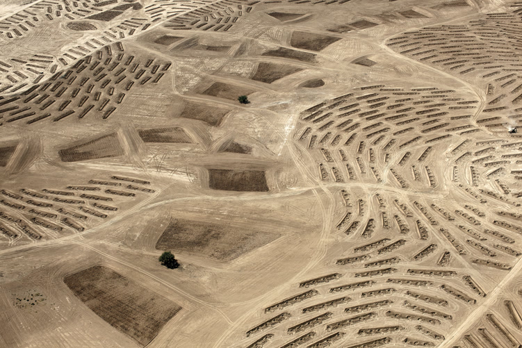
Sitting several kilometers north of Beersheba under a tent that had been hastily constructed by the Bedouin community of the former unrecognized village of Al-’Araqīb, I looked out over the transformations that had been wrought upon the land. In order to prepare for the planting of a new section of the Ambassador Forest—the green belt planned to encircle the outskirts of Beersheba—the Jewish National Fund (JNF) had bulldozed the Bedouins’ homes and buildings, uprooted the trees and gardens, leveled the terrain, and carved dozens of long incisions into the soil. Surveying the parched ground, I found it impossible to imagine the scene just a few months before, when the houses were still intact, and with the villagers and livestock moving about the landscape. I tried also to imagine how the space might look in twenty years’ time, when the trees had reached maturity and any last traces of what had once stood here were no longer visible.
Frustrated by my inability to fully visualize the situation on the ground, I decided it was necessary to see the land from above. I wanted a sense of how this area of radical upheaval fitted into the broad sweep of the desert. I hired a small plane to overfly the area and began to study the land, attempting to isolate the clues it had to offer. I was fortunate in having an Israeli pilot who was willing to share his knowledge of the desert’s history with me. Gradually I began to assemble the pieces of an interconnected puzzle. From above, the desert offered multilayered evidence of its geographical, historical, and political evolution. I could distinguish closed military zones, the traces of former unrecognized villages, the spread of afforestation, and the fields and buildings of Bedouin villages under threat, as well as the growing sprawl of Israeli settlements and the new military training camps and bases that had been moved to the area to protect them.
I was witnessing, in one sense, the results of Prime Minister David Ben-Gurion’s invocation to “make the desert bloom.” Even before the founding of the state, Ben-Gurion had recognized the potential offered by the northern Negev for an extended area of Israeli cultivation and settlement. Flying over the area nearly 70 years later, it was possible to see just how much of his prophecy had been fulfilled: the acquisition and alteration of the land through militarization, mining, industrialization, settlement, and afforestation. What one could also see—and what these images testify to—is the gradual enforced displacement of the Bedouins, the denial of their human rights, and the erasure of their traditional way of life.
After many flights across the threshold of the desert and southward through the Negev to the borders with Gaza and Egypt, I sat down to study the images I had made. Once I had witnessed the transformation of the land from an aerial perspective, it became easier to recognize the situation on the ground. With the aid of local experts, aerial specialists, members of the Bedouin community, and military strategists, I learned to identify the opposing forces on this contested terrain: man versus the land, and with this the attendant impact of climate change; the imposition of new technological advancements in an attempt to maximize the desert’s potential; and the Bedouin population that had lived on the land for generations versus the newly arriving settlers. For the Bedouins, the recent imposition of state regulations, backed up by new legislation and military might, threatens to destroy their way of life. A new dynamic has taken over on the threshold of the desert and the balance of man’s relationship to the land seems to be shifting. Rather than man adjusting to the dictates of the land, the land must now yield to the dictates and wishes of man.
